Noah’s Ark Found Near Ararat!
AUTHOR: Ruslana PETROVA

Do the new scans prove that an ancient human-made structure lies beneath Durupinar? What did the lowered robot record, and why is the team turning its attention to soil samples? Behind the sensational claim is a study that, as of October 5, 2026, has still not confirmed the discovery of Noah's Ark.
A new radar analysis and a report of footage from a borehole have once again drawn attention to Durupinar, the ship-shaped formation in eastern Turkey that has been linked to Noah’s Ark for decades. In early October, the Noah’s Ark Scans organization stated that there is a human-made structure underground. Independent verification and scientific peer review of the new conclusions are still pending.
The study is at its most intriguing stage: unusual signals have appeared, and it now has to be established what is actually causing them.
Beneath an outline resembling the hull of a huge ship, researchers are looking for something that can be extracted, identified and dated. This is where the test begins for one of the most persistent hypotheses in biblical archaeology.
The “ship” that has been waiting since 1959
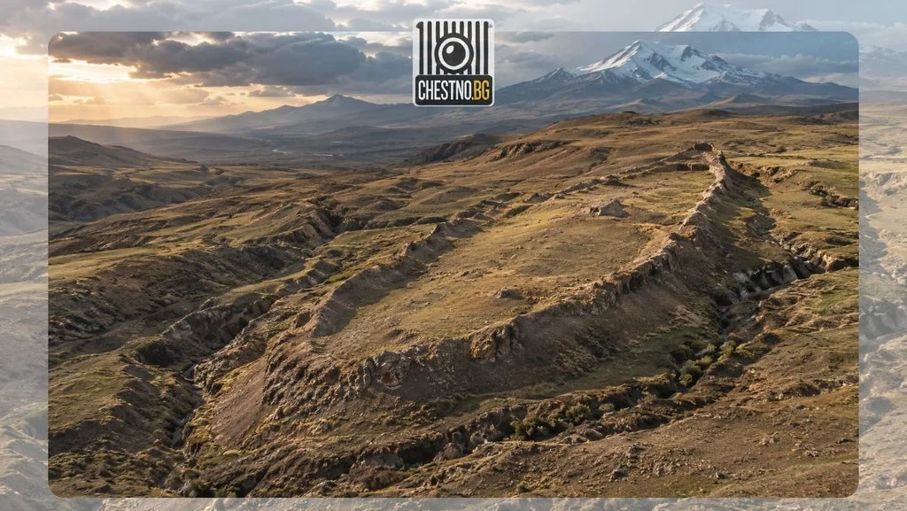
Durupinar is located near the village of Uzengili, in the Dogubayazit area. The formation is named after Turkish officer Ilhan Durupinar, who identified it in aerial photographs in 1959. From above, the elongated outline does indeed resemble a vessel stranded in the ground.
According to the project’s presentation, its length is approximately 157 meters. Supporters of the ship hypothesis compare it with the biblical 300 cubits, using the Egyptian royal cubit. This is a comparison dependent on the ancient unit of measurement selected, not a measurement that in itself establishes the object’s origin.
There is also a geographic detail that is often overlooked: Durupinar lies south of Mount Ararat. Genesis 8:4 refers to the mountains of Ararat, without coordinates for a specific location. The famous snow-capped peak and the ship-shaped formation are not the same location.
The probe stopped in a hard layer. What exactly was it?
On September 23, Noah’s Ark Scans reported boreholes with samples taken from depths of up to 18 meters. In one of the holes, at a depth of about 4 to 5 meters, the drill broke when it encountered an especially hard layer. Andrew Jones cited fossilized or heavily mineralized wood as a possible explanation, which must be tested in a laboratory. The team also reported material rich in organic matter.
This is where the narrative can easily acquire wooden beams, floors and decks. But a broken drill does not determine the composition of the material. To speak of wood, its characteristic structures or other reliable indicators must be identified. To speak of a ship, there must also be evidence of construction.
Even proven ancient wood would not solve the mystery on its own. It could have ended up in the ground in various ways. The archaeological context must show whether it was worked, how it was positioned and whether it belongs to a larger structure.
The new radar analysis: a strong claim, an open question
In a statement dated October 1 Dr. Khosrow Bakhtar, developer of the BakhtarRadar system, interprets the underground signals as organized structures. The team describes repeating linear and angular forms, possible passageways and enclosed spaces. According to Bakhtar, these features are incompatible with a model of solid natural rock. This is the assessment of the participating specialist, as disseminated by the organization.
In its October 3 report The Jerusalem Post notes that the conclusions have not yet been independently verified or scientifically peer-reviewed. The publication also conveys Bakhtar’s important clarification: he is convinced that the observed anomalies are connected to a single object, but he does not know exactly what that object is.
Therefore, “there is an unusual structure,” “the structure was made by humans” and “this is Noah’s Ark” are three separate claims. Each successive claim requires additional evidence. The researcher’s confidence does not replace this sequence.
The robot was lowered. Did it see a deck?
The report that a robot was used is the significant change from the original plan. On October 3, The Jerusalem Post reported that Noah’s Ark Scans had published footage from a Gopher robot sent into a borehole. The aim is to examine areas where the scans suggest an unusual internal structure.
This is not equivalent to footage of a ship’s interior. Lowering a camera is a method of verification, not its final result. A ship’s interior would be indicated by recognizable structural elements documented in their context.
Images and samples with clearly documented locations would be most valuable. This would allow specialists outside the team to compare what was seen with the radar interpretations and the geological features of the terrain.
Why does the radar “corridor” still have no walls?
Ground-penetrating radar sends electromagnetic pulses into the ground and records their reflections. The U.S. Geological Survey explains, that differences between materials and their moisture content alter the signal. This makes it possible to trace layers and boundaries beneath the surface.
This explanation concerns the principle of ground-penetrating radar surveys; it does not constitute an independent assessment of Bakhtar’s specific system. The general limitation remains: an image produced by processing signals needs to be verified on site.
Some of the popular images of Durupinar on the project’s website are labeled as the results of scans conducted in 2019. They must be distinguished from the new claims made in October 2026. A new publication may use an old illustration without the illustration itself showing a new discovery.
The three decks are in the text. They still have to be proven in the ground
In Genesis 6:16, the ark is indeed described as having three levels. This is why underground forms interpreted as internal decks provoke such a strong reaction. The similarity to the familiar account creates a sense of recognition.
But a geological layer and a built floor are different things. To move from one to the other, there must be evidence of materials, workmanship and the connection of structural elements. The biblical description may guide the hypothesis, but it cannot replace its verification.
The same applies to the widely cited figure of 4,300 years. In the reports reviewed, it is not supported by published radiocarbon dating of the new borehole samples. It cannot be used as the established age of a presumed ship.
The Oxford Radiocarbon Accelerator Unit clarifies, that the method determines when an organism lived, not necessarily when the material was used. In the case of wood, the growth of the relevant annual tissue is dated. The sample must be reliably identified, treated to prevent contamination and the result calibrated.
Even a date corresponding to a particular biblical chronology would not by itself establish who built a given structure.
The geologist who ruined the beautiful version
Durupinar has a scientific history that began long before the current drilling. In 1996, Lawrence Collins and David Fasold published a study in Journal of Geoscience Education, concluding that the formation is a natural geological structure. Fasold had previously taken part in the search for evidence of the ark.
The authors also analyzed samples presented as remnants of a ship. A purported iron element was explained as weathered volcanic minerals, while material identified as fossilized wood bark was described as transformed rock. The ship-like outline was examined in connection with folded layers and natural mineral deposits.
That study could not analyze samples taken three decades later. The new hypothesis must nevertheless show exactly where the geological explanation fails and what measurements refute it. What is needed here is accessible data that allows the competing explanations to be tested.
The next hope is ancient animal DNA
In its October statement Noah’s Ark Scans stated its intention to search for ancient animal DNA and to hold discussions with experts in ancient genomes. No results indicating that such DNA has been found have been presented.
If it is found, new questions will arise: what animals does it belong to, what period does it date from, and how did it end up in the layer being studied? Animal traces in the soil do not, by themselves, authenticate the biblical account. To establish a convincing connection, other explanations and sample contamination would have to be ruled out.
The Flood also leaves a trace we can read
One real object preserves another ancient account of salvation from a flood. The clay tablet K.3375 in the British Museum dates from the 7th century BC and contains part of the eleventh tablet of the Epic of Gilgamesh. In it, the god Ea warns Utnapishtim of the disaster and orders him to build a vessel for himself and his family.
This is evidence that the ancient text existed and that its motifs closely resemble those of the biblical story. Its decipherment caused a sensation in the 19th century. The connection between these accounts is part of cultural history. The question of whether there is a ship beneath Durupinar requires separate physical evidence.
When are the answers expected?
The project is led by Prof. Jenker Atilla of Sivas Cumhuriyet University. The university’s plan includes geophysical surveys, sampling and laboratory work, with the results to be presented in 2027.
The announcement of 1 October adds a target date for a more complete technical report on BakhtarRadar by November 2026. The laboratory results are expected by the end of spring 2027. These are plans announced by the team, not completed analyses.
Facts and Sources
Checked as of 5 October 2026. The project’s announcements, the university’s plan, media coverage, and publications on the geological interpretation and the methods used were compared.
- Noah’s Ark Scans via GlobeNewswire, 01.10.2026 the Bakhtar assessment, the intention to conduct DNA testing, and the timelines; a statement by the participants.
- The Jerusalem Post, 03.10.2026 the preliminary conclusions and the announcement of robotic imaging.
- Sivas Cumhuriyet University, 28.07.2026 leadership and program.
- Noah’s Ark Scans, 23.09.2026 the drilling and the broken drill bit.
- Presentation of the hypothesis and project gallery dimensions, location and earlier images.
- Collins and Fasold, 1996 geological analysis of the formation and earlier samples.
- USGS and the Oxford Radiocarbon Accelerator Unit principles and limitations of the methods.
- Genesis 8:4 and Genesis 6:16 the geography and the three levels in the religious text.
- British Museum, K.3375 the ancient tablet containing the flood account.
Comments